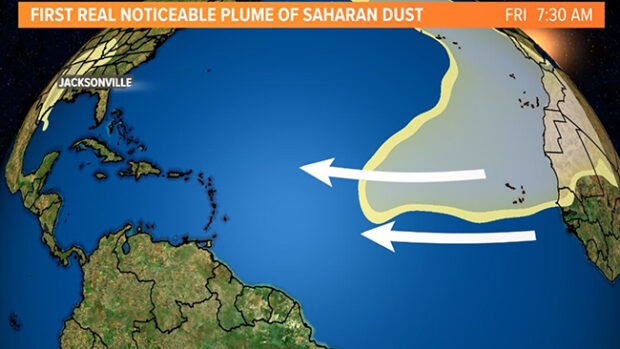
I have twice made the passage from Gibraltar to the Caribbean via the Canary Islands and during both trips we were surprised by the amount of fine sand or dust being carried by the wind off the west African coast. Our eyes got gritty, the decks got dusty, the scuppers had mud in them and white sails became a little discolored. In some years, this Sahara dust cloud can extend a thousand miles into the tropical North Atlantic. And, that’s what’s happening right now. The cloud rides a river of very dry air from the Sahara Desert and provides a sunshade over the tropical waters between the Canaries and Cape Verdes where tropical lows form, lows that can grow into hurricanes. Hurricanes need moist warm air and hot sea temperatures to develope and the dust cloud, bringing dry air and reduced sun energy, has a deadening effect on nascent low pressure systems. Combine this with the effects of El Niño in the Pacific, which also tends to dampen Atlantic hurricane formation, and the start of the hurricane season in the Atlantic is getting off to a promising start. That said, on Wednesday, NOAA gave the name Adrian to a tropical storm off Mexico’s west coast in the Pacific Ocean, which they forecast will become a hurricane today. It is heading out to sea now but stand by and keep a weather eye for Adrian to change course, as Pacific hurricanes often do. (The graphic above was created by WTLV News, Jacksonville, FL.)
Check out NOAA’s National Hurricane Center here.
See below for more on the 2023 Atlantic hurricane season.
Just Cruising with George Day
0
Sahara Dust Deadens Hurricane Formation
By Sandy Parks · On June 29, 2023You Might Also Like
Recent Posts
-
15 Boats Start Mini Globe Race Around the World
March 12, 2025 -
Mustang Introduces Award Winning Atlas PFD That Does It All
March 12, 2025 -
Survey of the Week
March 12, 2025


