Working with professionals who really understand oceanic weather systems and how sailboats behave at sea makes passagemaking faster, safer and more fun. Written by George Day for the July 2015 issue of BWS.
We set off from Newport, Rhode Island in early November with several other boats, all heading to the Caribbean more or less in company. The route was to take us southeast near Bermuda and then south to Antigua.
We were aboard Peter Johnstone’s 68-foot sled Mojo (this was in the pre-Gunboat days) and sailing with Peter and our mutual friend and BWS columnist Bill Biewenga. The weather forecast was for 48 hours of clearing northerly breezes following a frontal passage and then for another front that looked fairly benign.
The trick in the fall when leaving New England is to get well south of the Gulf Stream as fast as possible in a good weather window and then be able to duck into Bermuda if the weather turns sour or carry on to the Caribbean if the good weather holds, which it rarely does in November.
We had signed up with Commander’s Weather for pre-passage briefings and then daily updates and routing advice. Commander’s saw the weather window clearly so we set off. It was a breezy two days of fast running in the big downwind machine that was originally built for the biennial sleigh ride from California to Hawaii known as the TransPac. We were sailing at steady 12s and seeing the occasional 15 or more.
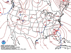
Once south of the Gulf Stream, the weather calmed down and the wind settled into the northwest where we wanted it. So far so good. But on the third day Commander’s alerted us to a frontal system with a small low developing just south of Cape Hatteras that was forecast to hit us and the rest of our little fleet the next day with southeasterly headwinds that could build to gale force. Not good.
We had two choices. We could sail as fast as we could toward Bermuda and hope to get into Georgetown before the storm hit us. Or we could take evasive action. We mulled it over for about 12 hours and then got the update from Commander’s. Go west, they said.
Our course was southeast. The low was forming to the southwest of us and heading northeast. The advice was to sail west over the top of the low and then turn southeast again. None of us like to change course on a long passage since that could add days at sea. But the prospect of beating into 25 knot headwinds was even less appetizing. So we altered course.
For the next 24 hours we simply let the angle of the wind dictate our course (with Commander’s concurrence). The winds around a low circulate in a counterclockwise direction so our northwesterly breeze gradually turned more west, then southwest as the low passed to the south of us and our headings changed accordingly.
By the time the low had scooted off to the northeast, passing just north of Bermuda, we were 1,000 miles south of Bermuda and making tracks for Antigua. Through the whole maneuver we had kept the wind on or aft of the beam and had found good sailing in fresh breezes.
Our sailing buddies were not so fortunate. The boats we had left Newport with all slogged into the gale determined to get to the shelter of Bermuda. They had 48 hours of very bouncy, blustery sailing and all were uncomfortable or worse. Maybe they had to get to Bermuda for some reason. Or, perhaps, they didn’t see the route around the low that would have slingshotted them toward the Caribbean.
Weather routing for ocean passages is a fairly recent development in the cruising fleet yet working with a company like Commander’s, Chris Parker and others can really make your time at sea safer, more comfortable and your passages as fast as possible.
The trick, of course, is to know how the weather systems you are likely to encounter will affect the wind direction and sea state. The aim is to avoid heavy weather as much as possible and to keep the wind as far aft as possible while still making headway to your destination.
All cruising skippers become pretty competent amateur weather forecasters and many use software and websites like PredictWind, PassageWeather, Ocens Weathernet4 and Grib Explorer, Nobeltec and MaxSea to help analyze the weather data generated by NOAA and other agencies. All of these are good aids to picking weather windows and planning routes. But, relying on your own assessment of what the data and software are telling you can be confusing, particularly if the various models and suggested routes don’t agree.
That happened not long ago on a passage from Bermuda back to Newport with my old friend Chris Bouzaid aboard his 60-foot sloop Wianiwa. We had PredictWind and MaxSea programs crunching the data we were downloading and the two programs did not agree. There was an occluded front hanging out north of us and beneath it was a nasty low that was being blocked by the North Atlantic High, so it was stationary and kicking up strong winds and big seas.
MaxSea told us to ride the southeast breeze north until we were east of Nantucket and then tack west for Newport. This didn’t look good. PredictWind told us to sail west-southwest from Bermuda toward the Carolinas for two days and then turn north with fair winds and the Gulf Stream carrying us northward. This seemed kind of far-fetched.
So, we called Commander’s and asked (paid) for their take on the situation. They agreed with PredictWind. So, we set off and sailed in the wrong direction for almost two days before shaping a course north to Newport. We had fine sailing, flat seas and a big boost from the Stream for 24 hours. We probably would have chosen something like this route on our own but having the blessing of the weather gurus really sealed the deal.
For the last four years, BWS has been one of the sponsors of the Salty Dawg Rally that uses Chris Parker for weather forecasting and routing. Of all the comments we get from the hundreds of sailors who have sailed with the Salty Dawg, the vast majority are praise for and thanks to Chris. In a difficult season for passagemaking in the North Atlantic, he makes a huge difference and has helped many a skipper make the right choices of when and where to sail.
Working with experienced, professional weather routers is the new way to go to sea and, in my view, it is a huge improvement on the weather guessing skippers do on their own.
Weather & Routing Services
MaxSea Weather Routing www.maxsea.com
Nobeltec www.nobeltec.com
Ocens Weathernet_Oceans Grib Explorer www.ocens.com
PassageWeather www.passageweather.com
PredictWind www.predictwind.com
Weather Routing Services
Commander’s Weather www.commandersweather.com
Chris Parker’s Marine Weather Center www.mwxc.com
Ocean-Pro Weather Services www.ocean-pro.com
Sailing Weather service www.sailwx.com
The Weather Guy www.weatherguy.com
Weather Routing, Inc. www.wriwx.com

