Capt John of skippertips.com highlights important sites to help keep your charts up to date.
All sailors like free sailing resources, but it can be tough to find those that are sea-tested, super reliable and up-to-date. Read on to discover three of my favorites that can help you plan an inland or coastal cruise, find a perfect anchorage, or determine the location of new shoals in your sailing or cruising area.
1. NOAA Chart Viewer.
How much money could the National Oceanic and Atmospheric Administration (NOAA) chart viewer save you? Try thousands of dollars. It’s not a replacement for nautical charts, but it will help you “drill down” on just those specific large scale charts you absolutely need for safe sailing or cruising. When cruising, you need large scale charts to enter coastal waters, make landfall, or anchor for the night.
That’s in addition to your electronic display. You need not carry hundreds of paper charts. But you must have those charts for navigation near the coast or inside sheltered waters for safe sailing and cruising. You’ll also need to make corrections to those charts (more on this later).
Find any chart in the coastal waters of the five major regions of the US and its possessions: Atlantic Coast, Gulf Coast, Pacific Coast, Alaska, and the Great Lakes. You can zoom in to see details on a buoy, light, marina, wreck or reef. Copy and paste to a Word document (or similar picture management program); then print it out and lash it to a clipboard. Carry it in your cockpit as a backup when you enter confined waters. See “Related Articles” below for more on how to use this valuable resource.
Resource Link:
NOAA Chart Viewer
2. NOAA Chart Dates of Latest Editions (DOLE).
Here’s a rule that I learned the hard way. Do not even think of purchasing a chart, chart portfolio or chart kit until you “check the DOLE”. It’s that simple. Vendors do not always carry the latest edition chart. And if they do not, that means you are about to spend your hard earned dollars on out of date stuff. Not good. Matter of fact, super bad. Out of date charts can get you into hot water fast.
Spend the sixty seconds or less to click on the Dates of Latest Editions (DOLE) link. It lists the up-to-the-minute latest edition charts with the chart scale, current edition date and “corrected through” information (local notice to mariner and notice to mariners).
Walk into a marine store like West Marine and ask to see the latest edition of a specific chart. Do not count on the clerk knowing what you are talking about. I’ve been told that the charts they carried were the latest and greatest. Sometimes they were, other times they were not. How can you tell?
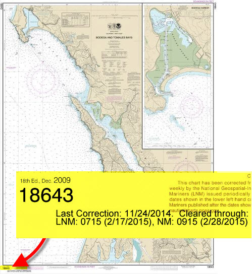
Look at the lower left corner of the chart. That’s the first place you should check no matter what chart you use (this applies to any chart anywhere in the world–US or International).
There, you will find the edition number and edition date of the chart along with correction information.
Charts are too expensive to make new editions each year. Corrections will be applied through the date stamped next to the edition date.
Compare what you see here to the DOLE. The DOLE rules. If that chart has an older date than the DOLE, it’s garbage.
Or perhaps frame it for a decoration, turn it into a coffee table top or make a lamp shade out of it. I’ve seen older charts turned into some pretty interesting stuff.
Do not trust older charts for navigation, except in exceptional circumstances. For example, let’s say you are cruising in a remote area with no access to a chart vendor.
Pull the chart you have available and compare the edition date to the DOLE. Your chart shows an earlier edition date. You must correct it so that it’s up to date and safe to use for navigation (see more below).
Resource Link:
NOAA Chart Dates of Latest Editions (DOLE)
3. US, Canadian and International Notices to Mariners.
Correct your charts in case new shoals appear, buoys and beacon positions or characteristics change, or new dangers obstruct a route since the date of the last survey (latest edition). Get on the mailing list for the Local Notice to Mariners (LNM) and Weekly Notice to Mariners (NM or NTM). Both of these services are free. Take the time to keep your charts corrected for worry-free sailing and cruising anywhere in the world.
US and Canadian governments issue notices to mariners specific to their waters. LNM are issued for each US Coast Guard District. The link below for US Local Notice to Mariners shows a map divided into USCG districts. Click on the district that contains your sailing or cruising area. Scan the LNM for navigational cautions, warnings, and a comprehensive list of the latest up-to-the-minute chart corrections (look in the LNM for “SECTION IV – CHART CORRECTIONS”).
If you sail or cruise (or plan to cruise) in International Waters, you should also use the Weekly Notice to Mariners (NM or NTM). Click the applicable link or links below. Put these into your favorites right now. Create a note on your laptop or mobile device similar to this: Check once a week during sailing season. It’s that important!
Resource Links:
US Local Notice to Mariners
Canadian Notice to Mariners
Weekly Notice to Mariners
~~~~~~~~~~~~~~~~~~~~
Add these three sailing resources to your favorites tool bar on your laptop or mobile device. Use these FREE cruise planning tools for safer sailing on the waters of the world.

