Here’s another great navigation tip from our friend Capt. John of skippertips.com…
Imagine that you are sailing offshore and approach your landfall from about 8 nautical miles–in pea soup fog. You have your sailing course set to the large sea buoy that marks the harbor entrance. But the sailing directions warn not to place too much trust in GPS. Several sailboats have piled up on the dangerous reefs on the approach. What now, skipper?
Aim for a specific buoy or landmark and if you are off by just a few degrees–or your GPS waypoint has an unknown error–you could “miss the mark”. And if you do, which way would you turn?
Use the “offset landfall” navigation technique. You will aim on purpose to one side or the other of the mark. Use this sailing solution to find your way to a buoy or channel entrance in low visibility or any other time you are in doubt of your position. Follow these five simple steps for safer sailing to backup your electronic black-boxes.

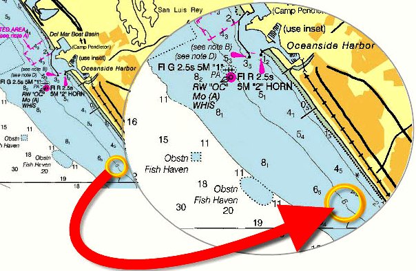
Look for depth curves that run almost parallel to the coast. Aim for a point to the right or left of the objective. Here, our objective will be lighted whistle buoy “OC” at the entrance to Oceanside Harbor. We will use a deliberate “offset” to the right and aim for the 6 fathom depth curve (chart shows soundings in fathoms and fathoms and feet). When our depth sounder reads 6 fathoms, we will turn northwest to follow the 6 fathom depth curve to the buoy. See steps below.
1. Study the Chart for a Prominent Depth Curve
Use the largest scale chart available for navigation. The smallest practical chart scale for this navigation technique will be about 1:100,000 (1:80,000 if possible). Coastal approach charts on these scales provide adequate detail for approach and entrance to major waterways (shift to a larger scale once you enter the waterway–see note below).
Look for curved, wavy lines–called “depth curves” or “depth contours”–that somewhat parallel the shore line. Scan along the depth curve to find a small number inserted somewhere along the line (see illustration above). That tells you the depth all along the contour curve (check your chart datum to determine whether depths are shown in feet, fathoms or meters).
Note: Use the largest scale available for safe sailing navigation. In sheltered waters just inside the coast, use 1:60,000, 1:40,000, 1:20,000, 1:10,000 or larger scales for navigation near shoal water.
2. Scan for Wrecks, Rocks, or Obstructions.
Scan up and down the depth curve and the possible approach routes to the depth curve to the right or left of the objective. Here you will not consider wind or current direction. Much more important will be a clear path on the approach to the contour curve and a clear path as you follow the contour curve to the objective.
Note in in the illustration, we have decided to aim to the right of our objective–buoy “OC”. We have scanned all along the depth curve to make sure that no shoals, wrecks or obstructions lie along the depth curve. There are two small fish havens (to the west) and a dangerous rock just inside the 2 fathom curve (to the east).
But these dangers lie well off the depth curve. As long as we stay along the depth curve, we should have a clear run to buoy “OC”. Put safety of sailing crew and sailboat first for sailing safety in all cases.
3. Determine an Offset Amount.
How far should you aim to the right or left? Use a more generous offset in isolated areas like a flat run of beach with few marks to confirm your navigation. This may be one to two miles. Increase the distance in thick weather (fog, heavy weather).
4. Stay Upwind to “Run Down the Curve”.
Sail upwind or up current if practicable and safe to do so. That way, when your depth sounder indicates arrival at the depth curve, you can turn downwind. Or, in the case of current that flows parallel to the land profile, aim up current and then you can turn and have a fair current and faster, easier passage to your objective.
5. Put Your Navigation Technique to Work.
Use the basics of good sailing navigation–a dead reckoning course labeled and plotted to your offset aim point. Estimate the approximate time of expected arrival at the depth curve. When you have run out your time, slow down and proceed with caution. If in doubt–head back out offshore.
Once your depth sounder indicates you are at the depth curve, turn and run down wind or down current (if this was a practical choice) to your destination. Again, estimate your new speed and revised time of arrival at your objective. Watch the depth sounder to help maintain the proper distance offshore.
Captain John’s Sailing Tip
Follow any depth curve at the slowest speed possible for a more accurate readout from your depth sounder. Post a lookout to scan for vessels, dangers, or other navigation marks ahead or ashore to verify your position.
~~~~~~~~~~~~~~~~~~~~
Practice this easy and fun sailing navigation technique in clear sailing weather so that you will be prepared for the future. Sail safe on the waters of the world this sailing season–wherever you choose to sail or cruise!


