Here’s another great navigation tip from our friend Capt. John from skippertips.com…
Sail over underwater canyons, mountains and valleys? You may not know that these massive areas exist beneath the waves. And they can create tidal currents on the surface that almost “boil” with high velocity. Learn the secrets to these natural phenomena and some sea-tested strategies to use for safer navigation.
What nautical chart symbols warn of strong currents, dangerous “erosion” rocks or busy shipping routes? Sail safer on the waters of the world when you know the most vital chart symbols used on your nautical and electronic charts. Read more below.
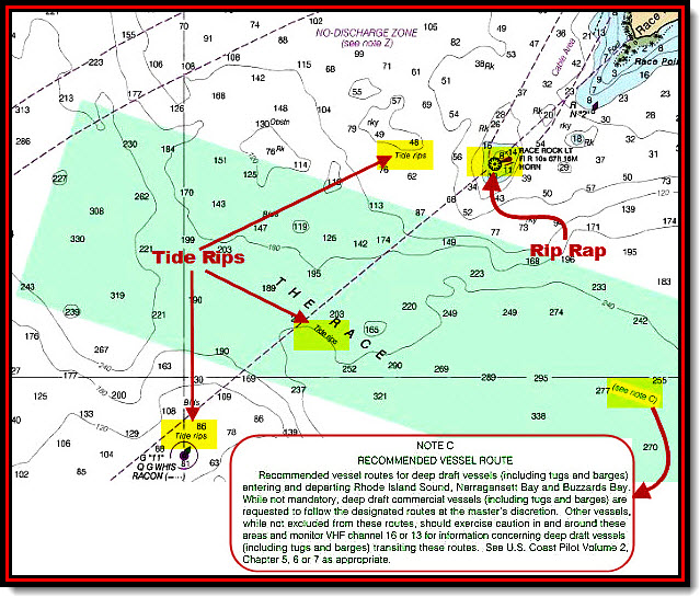
In some ocean areas, underwater hills or mountains rise on each side of a narrow passage. Look for underwater “channels” where the seabed drops from a few dozen feet to hundreds of feet (green tinted area in illustration above).
These underwater valleys can create high-octane currents on the sea surface (called a “race”) as the water “slots through” from one side to the other. New England’s Block Island Sound has a specific area called “The Race”, where depths change from just over 300 feet to less than 100 feet on the outer edges (see illustration above).
In placid weather, you can time your run to take advantage of a fair current that gives you an additional three to four knots of boat speed. In dusty weather where the wind blows against the current, elements in opposition can create high waves and tough conditions for small craft.
Check the current direction and velocity before you attempt to sail through a race. Time your run to take advantage of the slack water interval. This will be a short span of time where the current speed will be less than about 1/2 knot. In some areas with extreme tidal currents, this slack water period–also called duration of slack–may be just a few minutes long.
Realize that environmental factors such as heavy rainfall, frontal passages and winds can alter slack water time and the time and velocity of tidal currents. Predictions and forecasts are just that–they are estimates. Arrive in the area at least one hour earlier than the stated time of slack water.
Scan the water surface and look for current tails (disturbed water that flows down-current) near fixed or floating aids (buoys, beacons). Check the “lean” of buoys to estimate the current velocity. This will help you make a much more informed decision to sail through the pass or area of concern with confidence.
Don’t Let Rip-Rap Ruin Your Day!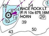
Note Race Rock lighthouse that marks the eastern side of “The Race”. The black dot designates the exact position of the light. But this symbol also shows an enclosed squiggly circle that surrounds the black dot.
Squiggly circles that enclose a black dot indicate rip-rap. Stones or other material have been placed around the base of the light structure to fight erosion. Some lights are exposed to waves in all weather. Without the addition of rip-rap, the light’s foundation could be damaged. Rip-rap serves as a sacrificial material to help prevent this.
Avoid sailing too close to any light structure that shows the riprap symbol. Like an iceberg, materials used to build the rip-rap can extend underwater much further than that shown by the rip-rap chart symbol. Rip-rap material can shift position after a heavy storm. Sail clear to avoid damage to your hull, keel, rudder or propeller shaft.
Highlights and Notes for Safer Sailing
Annotate your chart to make all features stand out. In the top illustration we show each instance of the Tide rips symbol and the rip-rap near Race Rock Lighthouse. And, we’ve also highlighted the chart note reference to Note C. Chart notes are “drill down” explanations of important navigational information that would be too extensive to place onto the navigable portion of the chart.
So, cartographers place chart notes in the margin or landmass areas of the specific chart. Read the chart notes if they lie close to the sailing route. They are often ignored, yet they provide valuable information that can affect sailing safety in a big way.
Note C warns us to keep a sharp lookout in the area for larger vessels and tugs and their tows. Although not marked with specific traffic 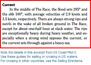 lanes, you can consider the Race to be a major shipping area. Keep a sharp lookout all around the horizon throughout the transit.
Consider an alternate sailing route to avoid the Race altogether. Back up your nautical chart or plotter with navigational publications. Notice that Note C references Coast Pilot 2.
US Coast Pilots give specific information for cruising or sailing in US waters. Find recommended routes, harbors of refuge, marinas and boat repair facilities, and much more (see excerpt to the right). Those cruising outside of US Waters should use the Sailing Directions for cruise planning.
~~~~~~~~~~~~~~~~~~~~~
Use these sailing navigation secrets for safer sailing on the waters of the world. Keep your sailing crew or partner safe and sound–wherever in the world you choose to sail or cruise!


