Here is another great tip from our friend Capt. John from skippertips.com….
What happens if you sail into an area with few prominent objects plotted on your nautical chart? Without radar aboard, you can still use bearings to bold sides of islands or land mass. And, this will serve as a perfect way to confirm your GPS navigation.
 Are you prepared for landfall on some of the world’s most pristine cruising grounds? Add these sailing tips to your “must have” navigation techniques for safer sailing worldwide.
In this article, you will learn how to…
– Shoot tangent bearings in just a matter of seconds for navigation safety.
– Use tangent bearings to show whether you are on or off your sailing course.
– Determine three vital “reliability” factors for bearing selection.
Keep sailing navigation simple, even in remote cruising areas where prominent objects are sparse or non-existent. You might choose to use points of land or the sides of an island for bearings. These “tangent” bearings can give you super fast positions and are handy for short- or single-handed sailing..
Use a hand bearing compass or even point the bow of the boat at the side of an island or landmass. Read the bearing and in just seconds, you have a bearing to plot onto your chart. But you will need to take care to select reliable land points or sides to shoot. Read on to discover why…
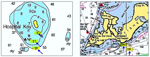
Which would give better fix quality for tangent bearings–the gentle, sloped sides of Hospital Key or the abrupt, steep sides of Fisher’s Island? Read more below
Look for Land Clear of Green Tinting
Look at these two illustrations of islands. Note that each land profile has a solid black line that surrounds the island. This solid black profile line defines the high water mark of the land mass.
If you see green tinting that extends in a direction away from the land mass, that indicates seabed that changes with the tide. At low tide, land such as sand bars or mud flats could be exposed; at high tide that land will be covered. Stay away from green tinted areas if practicable, because they will give much less reliable quality when you shoot bearings.
In the illustration, note that neither island shows a green tinted area to seaward of the solid black profile line. So, no need to worry about whether they will cover and uncover at different tidal stages.
Check for an Abrupt Rise from the Sea
But note the soundings on the approach to each of the two islands. On Hospital Key, the soundings are gradual, and the beach “shelves” at a slower pace as it rises up to the island. Islands with gradual slopes can be less accurate than those with more vertical sides. On Fisher’s Island the land rises from sea much faster; from 102 feet to 14 feet within about a quarter of a nautical mile. This means the sides of this island will be much steeper than those on Hospital Key and more reliable for tangent bearings or radar ranges.
What Will be the Tidal Effect on the Land?
As the tide rises, vertical cliffs or steeper shores (Fisher’s Island) maintain the same relative shape compared to those with gentle slopes (Hospital Key). This becomes more important in areas with extreme tidal ranges. Use steeper land mass if practicable for the most reliable tangent bearings and ranges.
*Also see “US Chart No. 1” on the left side of the member’s page under the red “DOWNLOAD LIBRARY” banner. This book contains hundreds of symbols and abbreviations used on nautical and electronic charts throughout the world.
Always check these three factors if possible before you take visual tangent bearings (or use radar for navigation). This will give you peace-of-mind that your bearings are reliable backups to your GPS navigation. Now turn to the next page to see tangent bearings in action!
Plot and label courses and positions so that your chart “reads” like a story. Make sure that your sailing crew or partner can take over anytime, anywhere with instant orientation.
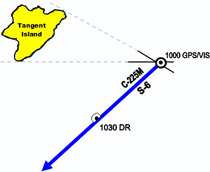
You are on a course of 225 degrees magnetic and a sailing speed of 6 knots. At 1000, you plot a GPS fix which shows you to be on track. You want to backup your GPS position. Tangent Island has no prominent objects, but it does have steep sides to the northeast and southwest. The tidal range in this area has a maximum of about 3 feet, which gives you good confidence in the bearings on the island.
You will use your personal hand bearing compass. You have checked the compass for deviation and it has 0 degrees of deviation and you know it will give accurate bearings. You will also stand clear of any magnetic influences when you take the bearings.
You shoot bearings to both sides of the island at 1000. Your visual fix and GPS fix coincide. Next, you want to plot a DR for the time that you intend to take your next fix (position). You intend to take another fix at 1030. At a speed of 6 knots, you will travel 3 nautical miles in 30 minutes (from 1000 to 1030).
Measure three miles on the right or left side of your chart. Make a dot and half circle three miles ahead of your 1000 position. Label the dot with the time and description (1030 DR).
Note our chart labels next to each position and on the top and bottom of the course line. We have added a speed label (S-6) to further clarify our intentions. Now you are “sailing navigation ready” for safe and sound sailing and cruising!
~~~~~~~~~~~~~~~~~~~~
You now know the three vital factors to use to determine the strength of an island or head land along the coast. Practice super simple sailing techniques like these for worry-free sailing and cruising–wherever in the world you choose to sail or cruise!

