Learn the nuances of these currents to help in your coastal navigation (published September 2014)
Most tidal currents we deal with on inland waters are reversing currents. That is, from slack water the current builds in the ebb direction to a peak value, on average about three hours later, then it starts to diminish in speed back to another slack—and over this full ebb cycle the current is flowing in more or less the same direction, tabulated as the ebb direction.
Then the current reverses, and carries out the same pattern in the tabulated flood direction. Usually in a reversing current, the ebb and flood directions are nearly opposite to each other, but it is not uncommon to be out of alignment by 10 degrees or so, and in extreme cases as much as 45 degrees—but even when misaligned there are these two unique directions that define the set in a reversing current.
In stark contrast, there are some locations in open inland waters, and in essentially all coastal waters, where tidal current behavior is quite different. These currents are called rotating currents. A pure rotating current rotates its direction of flow over the tidal cycle without changing speed. In a pure rotating current there is no peak current speed and no ebb or flow direction.
A pure rotating current, however, is rare. In most cases the current speed does change somewhat as the current rotates, and thus the pattern of the flow is not a circle, but an ellipse, in which case the long axis of the ellipse can be thought of as defining the ebb and flood directions, as well as the peak values to be expected.
The rotation is created by the interaction of two tidal waves moving in different directions. Either one of these waves on its own would create a simple reversing current, but where these waves cross the resulting current shows a rotation pattern at that location. The shape of the rotation pattern depends on the relative amplitudes, times and directions of the crossing tidal waves. In the Northern Hemisphere the rotation is usually clockwise. Running farther into a large open estuary with various channels, the same tidal waves will later create reversing currents.
A key point for navigators is to know and expect this different behavior of the current once sailing into large open bays or into coastal waters. Sometimes the official NOAA Tidal Current Tables alerts us to this with reference in the list of secondary stations to special tables or diagrams for rotating current stations, but in other parts of the world there is no warning. We just have to know it happens and search through the references for the data. On some Canadian charts, rotary current diagrams are printed right on the chart at the pertinent locations, but we do not see this often on U.S. charts.
Once we know the current rotates where we care about, and we find the data describing it, we are faced with how to use this information. The procedure for figuring time, set and drift of a rotary current is different and more involved than is the same process for a reversing current.
For a reversing current, we go to the Tidal Current Tables, find the nearest station, and look up the peak and slack times and speeds. Then use the interpolation table from the book to figure speeds at other times or use a shortcut like the Starpath 50-90 Rule. Or much easier, go online to tidesandcurrents.noaa.gov/noaacurrents/Stations and look up the data already corrected for secondary stations. Or easier still, open an echart program that includes a tides and currents utility, and click the place on the chart you want, set the calendar and clock, and read off the current for that specific time, or print a plot of current versus time for a day or so. This feature of electronic charting is one of its strong selling points for those who sail tidal waters.
For rotary currents, however, none of these easy methods work. Furthermore, you must have the official NOAA Tidal Current Tables at hand. Abbreviated versions rarely have the needed information, it is not online and it is not included with echart current utilities. Rotary current predictions are too complex to be tabulated, so we are left with approximations.
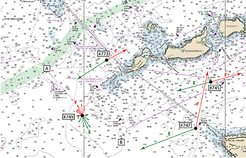
To show the process, we look just southwest of Cuttyhunk Island in Rhode Island Sound (Current station #749). A section of Table 5 from the Current Tables shows how this current rotates at this location. The currents are not strong at this location, but other places rotating current can be quite strong. On Nantucket Shoals or the entrance to Strait of Juan de Fuca, or many places in Alaska, rotating currents can routinely be well over two knots.
Also note that within just three to six miles of this rotating current there are three stations with purely reversing currents. One just inside Buzzard’s Bay (#773) and two just inside Vineyard Sound (#747 and #745). There are numerous examples around the country where pure reversing switches to rotating in just a few miles.
The main reference to using the data are the Instructions to Table 5 in the Tidal Current Tables, but I venture to guess that not all navigators who might benefit from the information have seen them, so we offer a brief summary here till they get a chance.
The current speeds shown in Table 5 are the monthly averages. The times of each current are relative to the time of max flood at Pollock Rip Channel, which is a primary reference station in this area. Thus, that one time sets the times for the currents at each hour after that. If for example the max flood at Pollock Rip occurred at 0551, then the average Cuttyhunk current at 0951 (4h later) would be 0.5 knots, setting toward 146 T. Since we know the current each hour, if we knew the time period we expected to be in this current we could figure the net tidal vector and from this figure our CMG and SMG as we transited the area.
But we are not done. These are average speeds, and just as with reversing currents, the speeds are stronger at spring tides (new moon and full moon) and weaker at neap tides (quarter moons, which appear in the sky as half-moons). As a rough rule, spring tides give rise to currents about 20 percent larger than the average, and neap tides yield currents about 20 percent lower than the average at any particular location. And this can be fine tuned even farther by taking into account the location of the moon in its orbit at these phases. When the moon is closest to the earth (perigee) at the springs, the x 1.2 factor increases to x 1.4, and when the moon is farthest from the earth (apogee) at the neaps, the x 0.83 factor (1/1.2) is reduced to x 0.71 (1/1.4).
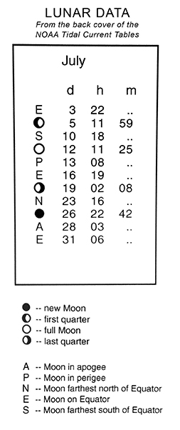
With reversing currents we do not have to worry about this. The astronomical influences are built into the current table predictions. But for rotating currents we get only the averages and have to apply the astronomical corrections ourselves. The needed astro data are on the inside back cover of the current tables and also online. This year, for example, July 12 was full moon and July 13 was perigee, so we expected currents throughout the region to be some 40 percent larger than average on these days, which you can see in the current tables for all reference stations in the region. On these two days, however, we would need to increase the tabulated rotary currents by this factor ourselves.
Sailing in rotary currents takes extra work, but knowing how to figure them and how to account for their influence on neighboring reversing current helps you make good predictions ahead of time that in turn helps you interpret what you see on the GPS.
David Burch is the director of Starpath School of Navigation, which offers online courses in marine navigation and weather at www.starpath.com. He has written eight books on navigation and received the Institute of Navigation’s Superior Achievement Award for outstanding performance as a practicing navigator.


