Know where you are when your most important systems fail (published January 2014)
It’s a question of if, not when your main navigation equipment fails. Of course, it usually tends to do so right when you need it most, such as just after you’ve committed to shooting that chancy inlet in low visibility (this is not recommended anyway, but hey, you’re the skipper). But it can also fail under perfectly normal circumstances due to any number of causes—someone drops a fork across the battery terminals, a fuse blows and you forgot to check whether or not you had a replacement on board, etc.

For some sailors losing a piece of navigation equipment is just a minor inconvenience to be remedied at leisure in better weather or when a suitable jury rig can be devised. For many, though, this could be a significant problem.
POSSIBLE FAILURES
The difference in being ready for a navigation breakdown lies in preparation, which is what prudent seamanship, and this article, is all about. The best way to think about what gear is worthwhile and practical is to look at the possible failures first, then consider what sort of preparation can remedy them. A consideration of the likelihood and risk of each failure also helps us determine how much money and effort we should spend on reducing that risk. As you’ll see, it’s actually surprisingly easy and affordable to be prepared for nearly any serious navigation system failure or even a cascading sequence of failures with this technique—so let’s get started.
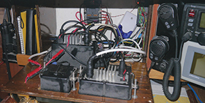
There are several layers to modern navigation technology that enable us to find our way with an astonishing level of precision. The first layer, from our perspective, is the electrical and wiring systems aboard ship. These can fail occasionally for a variety of reasons, and eliminates or at least limits the use of all electronics that do not run on replaceable batteries. More to the point, the wires and connections fail far more frequently, and though this is much easier to fix, it often results in the disabling of that device until the fix can be tracked down and implemented.
The second layer is the device itself, which is a complex piece of computing equipment. These are generally reliable but fail more frequently than people actually realize. The third layer is the data on the device. This can be damaged with nearby lightning strikes, the loss or damage to an important chip or card with the chart data, or accidental erasure of that data by a clumsy user or errant button press. Failure of one of these first three layers is quite likely to happen to you at least once in the course of an active sailing season.
The final layer we get to for your navigation equipment is the technology outside your boat. The main part of this is the GPS/GLONASS satellite infrastructure. While this is unlikely to fail in the near future, it is possible that you will encounter situations where the data is deliberately misleading if you sail to parts of the world anywhere near where major nations are engaged in conflict. Also, it’s prudent to be prepared for the failure of this system in case unforeseen circumstances arise.
BE PREPARED
Proper preparation for these circumstances involves considering each layer and what remedies to have in place should it fail. So, let’s take them one at a time.
Failures of the main electrical system can be remedied, in part, by having at least one navigation tool that has it’s own power supply. This could be a handheld GPS unit that accepts double-A batteries, an iPad with a solar USB charger, or something similar. These will often be combined with paper charts to be used effectively.
Regardless of whether or not you are using one of those standalone devices for your primary navigation (your author uses an iPad, for instance), the device, it’s data, or it’s necessary connections could also fail, so the obvious remedy here is to have a second, often functionally different, device as a redundant backup. A good example would be a pair of handheld GPS devices, a laptop with an external GPS antenna as a backup, your AIS GPS if a separate display is available, etc. Of course, make sure that one of your devices doesn’t also rely on the main power supply or both of them will be vulnerable to the first layer of failures. Many sailors forget this principle and think that since a power-hungry laptop and chartplotter are separate devices they are properly prepared. Not so if the main power goes out and doubly not so if the chartplotter is the source of GPS data for the laptop.
Failure of the data on your device can make it essentially unusable in some cases, or simply a numeric GPS at best, so it’s always prudent to carry some paper charts to back up your electronic ones regardless of how much redundancy you have on the electronic side. Also, don’t forget to keep track of your important waypoints and navigation marks in a navigation log as well.
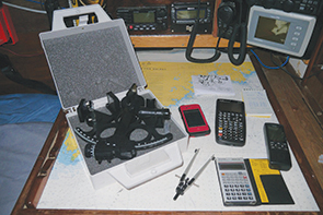
Failure of the global GPS/GLONASS system is another possibility. The redundancy provided by both systems only goes so far and jamming, interference, military action, political instability or a host of other possibilities can cause the systems to either stop functioning in your area or give inaccurate results. The only real solution to this—until eLORAN comes along—is to have a sextant, tables and paper charts onboard, know how to use them and practice occasionally. One of my favorite solutions to the difficulties of paper computation and table lookups is to use a navigation computer—either software for the modern graphic calculators or the fantastic iMariner app available for smartphones, which is even better. I put the odds of your calculator failing WHILE the main GPS/GLONASS system is also out of operation at about the same as soaking your lookup tables to the point of uselessness, so I consider the situations equivalent. One is certainly much less effort. Realistically speaking, this is the most practical way for a modern mariner who traditionally navigates via GPS to have an affordable, simple backup that is useable with a minimum of practice. But practice, especially with the sextant itself, is still needed. Sun shots can help you navigate longer journeys, with pilotage getting you to shore.
With these principles in mind, here are some practical recommendations for long-term navigational reliability. The simplicity of the list may surprise you.
1. A sextant (an inexpensive one is perfect as a backup) plus paper charts and a navigation calculator or the iMariner app. Remember, don’t forget to practice. The calculator makes the math a cinch, and you don’t need to carry heavy and expensive books of tables around.
2. A handheld, battery operated, waterproof GPS unit, with or without charts onboard. You can use the paper charts with this as well. Don’t forget spare batteries for the unit and make sure to store them in a cool dry place so they will be usable when you need to.
3. A main navigation computer, iPad with suitable software and charts, or chartplotter. Include a backup GPS receiver, which are generally much more affordable than the plotter, or a cable to connect your handheld GPS to your NMEA input easily.
By employing these solutions, if your antenna, main workstation, or electrical system fails, you have one level of electronic redundancy and a fallback level of GPS-free redundancy as well. Best of all, it’s likely you already own a significant portion of these devices and are familiar with their operation. Carrying too much complexity is as much a hassle as not having enough redundancy, so don’t go overboard with excessive gadgetry. Just have a simple, straightforward plan to fall back on based on different failures, teach your crew, and practice as often as is reasonable with the backup systems.
Daniel Collins, an ASA certified sailing and navigation instructor and amateur extra class radio operator, enjoys experimenting with marine electronics while solo sailing his Chinese lug rig schooner Aletheia. He is also actively involved in community-driven social change and has founded the Halifax Art Boat Project, an artistic experiment in boatbuilding based in Halifax, Nova Scotia. You can reach him at daniel@oddasea.com and explore the Halifax Art Boat at facebook.com/halifaxartboat.

