Heading to the Caribbean from the East Coast always incurs the bitter and sweet reality of a Gulf Stream crossing. It will certainly have elements of one or the other (published November 2015)
Whether racing or delivering boats to or from New England or further south along the East Coast, the western North Atlantic often has its own set of idiosyncrasies even when the weather is favorable. From the East Coast of the U.S. to Bermuda, and points south, sailors have more to consider than just the weather. One of the major hurdles that is always encountered along the way is the Gulf Stream. I must admit that I’ve lost track of how many times I’ve crossed the Gulf Stream. Forty? Sixty? More? The count is certainly not less, but the number is far less important than the lessons learned. Sometimes, one can catch a favorable current. Perhaps it’s a meander flowing in the same direction to the south or southeast that we would be attempting to travel as we departed New England. Perhaps we could catch a ride on the edge of a warm eddy and get to a favorable meander. More often than not, while doing deliveries we would just try to get across that capricious stretch of water as quickly and painlessly as possible.
It’s true enough that as one travels south out of New England in the fall or early winter, crews look forward to the warm water and sometimes-sunny skies of the Gulf Stream. But those warm waters can conceal a double-edged sword: stronger winds, steeper waves and increased squalls. It isn’t always so. Much depends on the temperature and direction of the wind. When cold northerlies are in vogue, the colder air aloft sinks as it gets to the warm water of the Stream, increasing the winds at the surface. Winds that might otherwise be in the 30 to 35 knot range, suddenly can become 50 knots or more over the northern wall of the Stream, and the colder the air, the stronger the winds along the north wall. Winds blowing against the flow of the current will also create a much steeper wave pattern, adding to the drama.
One needs to give careful consideration to the strategy about how to approach and cross that major oceanographic feature regardless of where the point of origin is along the East Coast. Currents can move between two and five knots in some places, and the meandering warm water stream will definitely have a strong influence on progress. In addition to the actual speed and direction of the current affecting the speed over the ground, the current influences the size and shape of the waves. If winds are strong and pitching against the strong current, the waves will be particularly steep and high. Strong northeasterlies can turn the Stream into a living, waking nightmare. Conversely, strong to moderate winds with the current moving in the same direction can turn the passage into a sleigh ride, ideally with warm, sunny skies dotted by small puffball fair weather cumulus clouds.
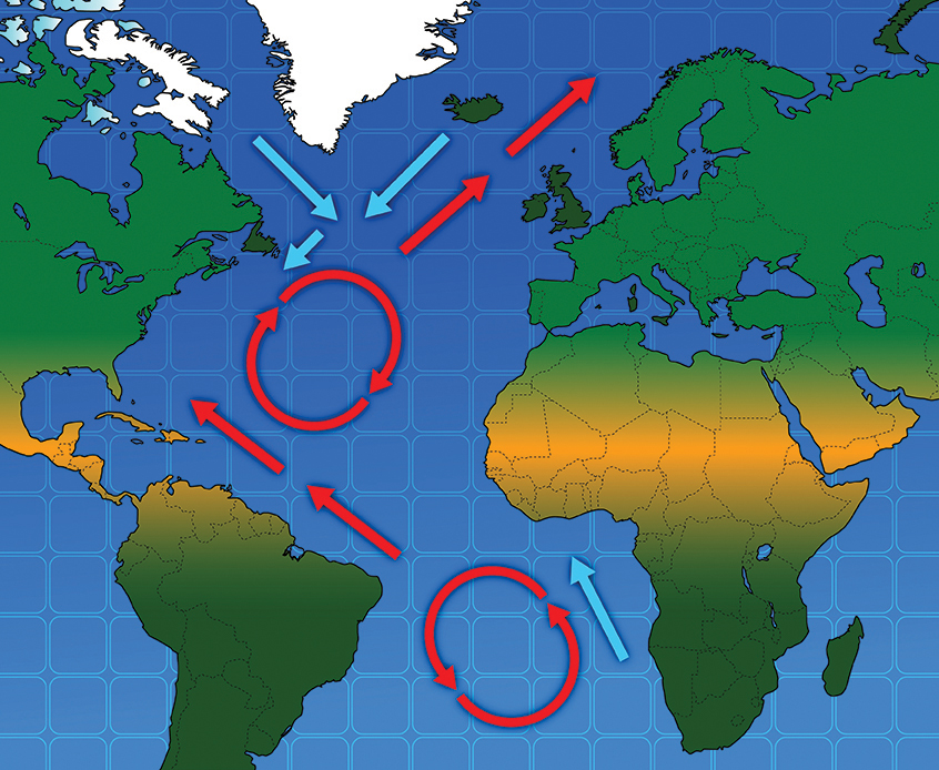
Consider for a moment, how the direction of the current varies wildly in an oceanographic feature like the Gulf Stream. On the large scale, there are meanders in the overall direction of the current as well as both cold eddies flowing in a counterclockwise direction and warm eddies flowing in a clockwise direction. On smaller scales, currents shift direction from place to place, not unlike the currents in a rapidly flowing river. Now, consider how the wind maintains a general direction, but that, too, shifts by 10 or 20 degrees as clouds go overhead or other changes take place. Given the fact that wind blowing over a current will help to determine the size and shape of waves, it becomes easy to understand why the sea state is often confused and radically changing in the Gulf Stream. On more than one occasion that led to steep, breaking seas as we entered the current.
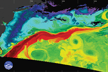
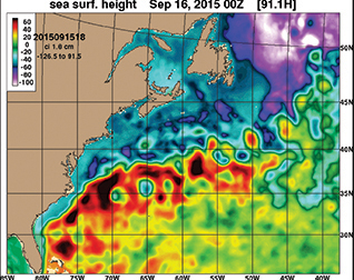
Approaching the Gulf Stream from north or south, small fair weather cumulus clouds may be among the first signs that the warm current is getting closer. There are, of course, a number of websites that will offer infrared images of the Gulf Stream to help you determine its location by taking satellite images of Sea Surface Temperatures (SST). A few sites would include Johns Hopkins’ site (http://fermi.jhuapl.edu/), the Rutgers website (http://marine.rutgers.edu/cool/sat_data/?product=sst¬humbs=0), and the U.S. Navy’s site (http://www7320.nrlssc.navy.mil/GLBhycom1-12/ATLANTIC.html). Among other means of identifying its whereabouts, altimetry data (Sea Surface Height or SSH) will confirm the Stream’s location by measuring the height of the water from space. Amazingly enough, the height of the water can vary as much as 3 feet or more, depending on the current. Satellites have been designed and equipped to measure those height anomalies.
From the deck of the boat, however, other signs may include Sargasso weed streaming across the water’s surface strung out in long patches. Wildlife changes, as well. Portuguese man o’war will become more numerous in the warmer water, and it might be a good time to deploy the fishing poles if you’re not in a hurry. Tuna, dorado, flying fish and other species often like to cruise through the warmer water, especially where the temperatures change quickly.
The warmer water has other implications, as well. The warm air rising off the surface of the water, will not only create those little puffy clouds, it will also increase the likelihood of lightning and thunderstorms at night, adding power to any squall line that may be approaching ahead of cold fronts. The Gulf Stream will definitely deserve some respect, and it will get your attention.
While apprehension may run a bit higher as one approaches the Stream, understanding how it works will help sailors utilize the benefits while avoiding the pitfalls—at least most of the time. As a source of warm, rising air, it can be assumed that if squalls are present, they will increase more on the downwind side of the Stream. The warm, rising air adds energy to a weather system. Typically, weather often approaches from west, and as cold fronts pass over the Stream, the added warm air increases the risk of stronger winds and squalls downwind from the Stream.
Positioning yourself within the Gulf Stream and the associated weather pattern is perhaps the most important consideration when transiting the Stream, but it is not the only consideration. Thinking ahead will help you to further avoid problems. If you have the expectation that cooler air descending from aloft will increase your wind speed, you will probably want to shorten sail early especially at night when the cooler air aloft will add even more wind at the warmer surface of the Stream. If the waves are expected to be higher and/or steeper, and you’re flying a spinnaker, it may be worth considering downshifting to a stronger or smaller chute or other headsail. Rigging is also affected. If available, runners and an inner forestay should be engaged early and the backstay checked.
It’s not only on deck that is changed as you enter the Gulf Stream. Life down below will also be affected. Make sure meals are prepared in advance, keeping safety in mind. Boiling water on the stove can be dangerous in a steep seaway. In addition to fixing meals appropriate for preparation in a seaway, cooks may want to wear foul weather gear below while cooking to help avoid getting burned. If crew are susceptible to seasickness, taking seasickness medication early may help to avoid that problem.
The Gulf Stream is part of almost any trip to the islands from the East Coast of the U.S. It’s not something to be feared but rather a part of nature to be respected. Getting the strategy right for your passage can be a great source of enjoyment and give you a better understanding of how the ocean and weather work together on our planet. The effort you put into planning that transit will pay big dividends as you increase your understanding and efficiency and avoid potentially costly mistakes. Whether your experience is bitter or sweet will depend largely upon those efforts.
Bill Biewenga is a navigator, delivery skipper and weather router. His websites are www.weather4sailors.com and www.WxAdvantage.com. He can be contacted at billbiewenga@cox.net.

